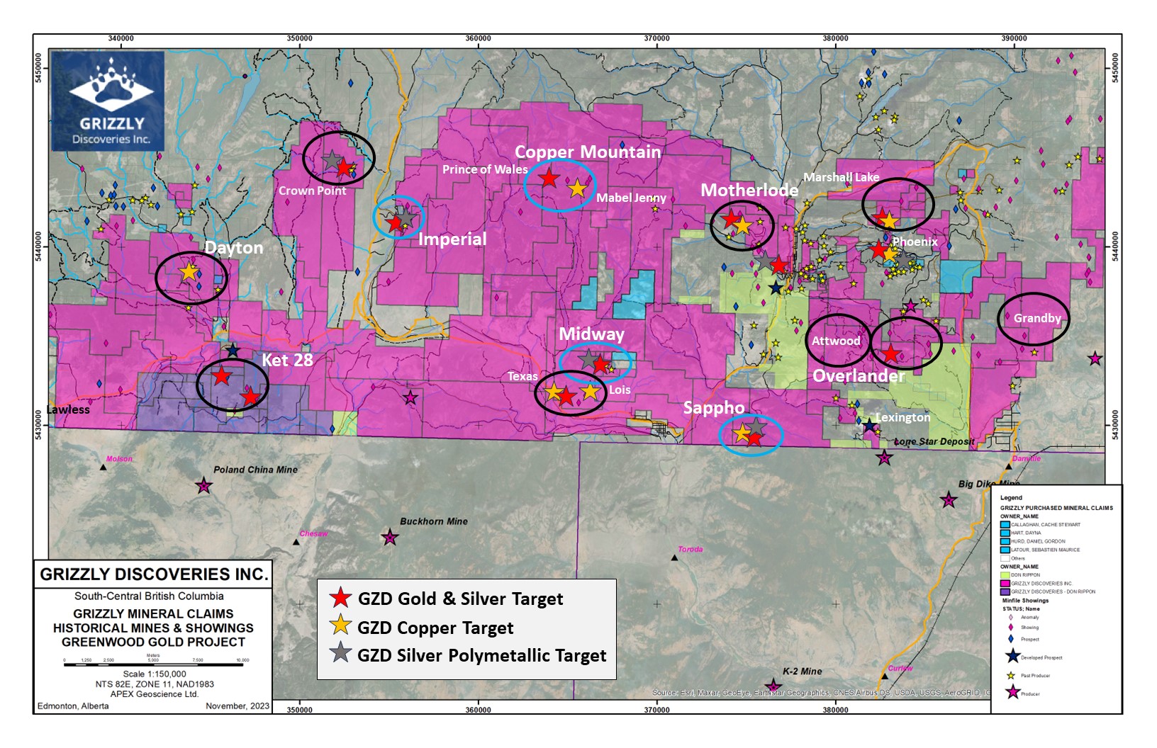
OVERVIEW
Since 2008, the Company has consolidated a previously fragmented historic mining camp with mineral claims covering approximately 180,000 contiguous acres in South-central British Columbia, in the historically productive Republic-Greenwood Gold District, abutting the border with the United States.
The Republic-Greenwood Gold District has historically produced an aggregate of more than 6 million ounces of gold (“Au”) prior to Grizzly’s acquisition of the Greenwood Project. The Greenwood Project also sits less than 10 kilometres (“km”) north of the Buckhorn Gold Mine, Kinross” producing gold mine in the US, which had a 1.2 million ounce (“oz”) gold resource at 16 grams/tonne of gold (“g/t Au”) at start up in 2010, and less than 50 km north of the Golden Eagle Project, having greater than two million ounce gold resource. Based on compilation, assessment, and exploration work conducted by the Company, Grizzly believes that a large portion of the Greenwood Project lands over a continuation of the same geological structures as these two mines.
The Greenwood project consists of a number of Company managed exploration projects:
1
MIDWAY
2
IMPERIAL
3
SAPPHO
4
MOTHERLODE
5
KET 28
MIDWAY
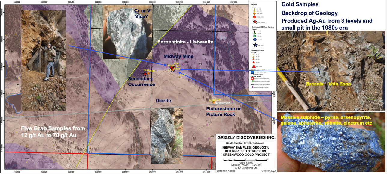
Grizzly Discoveries optioned the mineral rights to 317 hectares in seven (7) mineral claims in the Greenwood area, BC including the historical Silver (Ag)-Gold (Au)-Lead (Pb)-Zinc (Zn) Midway Mine and the Picturestone Quarry, which are about 4 km northwest of the town of Midway in the Kettle River Valley area of BC. The Midway – Picturestone mineral claims are strategically located within the Company’s Greenwood land holdings and in particular the Company’s Midway lands.
The Midway Mine and the Picturestone (aka Picture Rock) Quarry area have seen intermittent exploration and mining since the late 1800’s through to as recent as 2012. In the case of the historical Midway Mine, limited underground and open pit development has occurred. The Midway Mine and the Picturestone Quarry are situated within the “Midway Window”, a structural zone within the Toroda Graben exposing Late Paleozoic to Jurassic sediments, volcanics and intrusions, including the Knob Hill and Brooklyn formations, centered on an old thrust fault in a similar setting to the Golden Crown and Lexington Mine area near Greenwood, BC.
An extensive rock and soil sampling program along with new geological mapping during 2023 has been conducted in preparation for drilling this fall. The work has yielded two new showings identified near the historical Midway Mine including up 5.64 g/t Au from a showing 400 m to the north of the Midway Mine and a second showing along an apparent fault structure with 4.19 g/t Au from a grab sample collected about 375 m to the west of the Midway Mine (Figure 2). At least 6 new areas with anomalous gold (> 100 ppb Au), silver or copper in soils has been identified across the Midway Mine Property with follow up work continuing to be conducted (Figure 2).
To date, gold-silver-base metal mineralization appears to be related to veins and stockworks at contacts between altered ultramafic-carbonate rocks (listwanites) in contact with diorite intrusions in a complex structural setting, with the intersections of structures playing a key role in the localization of alteration.
Highlights from 2022 Exploration Program on the Midway Mine:
- A total of 18 additional and new selective rock grab and composite rock grab samples from outcrop collected from the Midway Mine-Picturestone area, with 8 of 18 rock grab samples from outcropping mineralization in the Midway Mine area yielding a range of 0.119 grams per tonne (g/T) gold (Au) up to 12.85 g/T (or 0.375 ounces per ton [opt]) Au.
- Three (3) of the 18 new selective rock grab samples from the Midway Mine area yielded from 248 g/T silver (Ag) (7.2 opt Ag) up to 2,700 g/T Ag (78.8 opt Ag), with highly anomalous and associated lead (Pb), zinc (Zn), copper (Cu), arsenic (As) and antimony (Sb).
- All highly anomalous samples are from outcrop and characterized by the presence of abundant pyrite, arsenopyrite with visible galena and sphalerite in a siliceous chalcedonic host. The mineralization is hosted in polymetallic veins and altered wall rock that display the presence of Pb, Zn, Cu, As and Sb, and are likely epithermal in nature. Mineralized veins with northwest and northeast orientations were noted.
- Host rocks are altered with disseminated sulphide and are likely altered sedimentary rocks to altered intermediate intrusions including quartz-feldspar porphyry and diorite.
- A selective rock grab sample from outcrop 200 m west of the main Midway Mine yielded 15.85 g/T Au (0.462 opt Au) and 1,530 g/T Ag (44.6 opt Ag), illustrating that there is potential for additional high grade mineralization in the area.
Selected geochemical highlights for 12 rock grab samples* collected in the Midway Mine area.
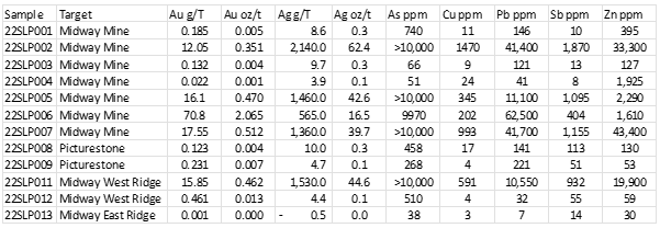
*Selective rock grab samples are illustrative of the tenor of mineralization for the material collected but may or may not be characteristic of the overall mineralization of the deposit as they are selective in nature.
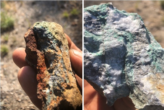
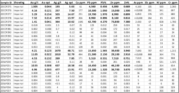
IMPERIAL MINE
Discovery of the Imperial area mineralization dates to the late 1890’s with initial production first recorded in the early 1900’s. The historical Imperial Mine has seen intermittent production from the early 1900’s to as recently as 2011. According to the BC Government minfile records the historical Imperial Mine produced a little over 9,200 oz of silver and more than 20,000 pounds each of lead and zinc. The production records cover the period from 1914 to 1949 (BC MINFILE 082ESE113). Details of the total production during the 1990’s through to the 2000’s by the Cannon family is unknown. Open pit and underground mining were conducted during the period.
The historical Imperial Mine, is located on the eastern margin of the Kettle River, is underlain by a complex north-trending graben that exposes Paleozoic metasedimentary and metavolcanic rocks...
At the Imperial Mine, the property is bounded to the north and south by the Nelson intrusions...
The economic minerals of interest are mainly galena, sphalerite, and pyrite, all of which contain gold and silver...
Some gold occurs with the silver in the sulphides, along with pyrite and arsenopyrite but gold is also known to occur in a steep set of fractures...
The Imperial Mine target area is 815 ha (2,015 acres) and includes the Riverside Past Producer and Commonwealth showing north of the Imperial Mine...
Limited Intermittent exploration, including some trenching, diamond drilling and small open pit mining has been conducted over the last 50 years...
At the historical Imperial Mine area, during the 2023 exploration season, a total of 50 new rock grab and rock chip samples were collected...
In February 2023, the Company announced results from grab samples collected during the exploration season 2022 at the historical Imperial Mine, with the following highlights:
- A total of 83 new selective rock grab and composite rock grab samples...
- A total of 10 of the 83 rock grab samples...
- The 10 new selective high-grade Ag-Au bearing rock grab samples...
- All highly anomalous samples are characterized by the presence of abundant and visible pyrite...
- High levels of chromium and nickel reflect the presence of altered ultramafic rocks...
- The Imperial showings, including the veins and pods of mineralization...
- The grabens are characterized by north-northeast trending normal faults.
- The geological setting and style of mineralization at the Imperial Mine bears a strong resemblance...
- The Company is planning surface and underground rock and soil sampling...
Selected geochemical highlights for 24 rock grab samples* collected from the Imperial Mine area.
*Selective rock grab samples are illustrative of the tenor of mineralization for the material collected but may or may not be characteristic of the overall mineralization of the zone sampled as they are selective in nature.
SAPPHO
The Sappho prospect, on which the Company conducted extensive exploration in 2009 and 2010, has yielded strong evidence of copper-gold-silver-platinum-palladium (“Cu-Au-Ag-PGE”) alkalic porphyry mineralization. Exploration at the Sappho zone has resulted in numerous high grade samples from the historic workings. However, the nature of its origin and the surrounding geology is not fully understood. The remaining area of the Sappho claim block is relatively underexplored compared to the extensive work at the main showings.
Three well documented surface copper occurrences in the northeastern portion of the complex yielded numerous high grade selective grab sample results including up to 8.28% copper (“Cu”) 298 grams per tonne (“g/t”) silver (“Ag”), 2.2 g/t gold (“Au”), 27.1 g/t Platinum (“Pt”) and 2.57 g/t palladium (“Pd”). All three occurrences yielded multi gram Pt and Pd values. The Sappho prospect is unusual relative to most British Columbia platinum group elements-bearing alkaline intrusive complexes, in that it contains Pt concentrations greater than Pd and Au. As reported in the Technical Report, government geologists have conducted extensive geochemical and mineralogical work on the Sappho alkaline complex and associated Cu-Ag-PGE-Au mineralization and, based upon textural and geochemical evidence, suggest that the mineralization is late magmatic or magmatic-hydrothermal in origin and bares mineralogical traits most common in alkaline porphyry style associated metals.
A drill program conducted by the Company in 2010 targeted two showings at the Sappho prospect, the Main and Northern showings, with a drillhole beneath each showing and two additional drillholes testing two proximal blind magnetic features with no previously known mineralization. The two holes beneath the Sappho Main and Sappho North showings intersected weak but anomalous Cu-Ag-PGE-Au. The best intersection was provided by drillhole 10SP03, which targeted a blind magnetic anomaly close to the Bodie Mountain fault and yielded a wide anomalous interval of 0.28% CuEq over 93.5 m core length including a higher grade zone of 0.38 % CuEq over 63.5 m core length that is comprised of 0.12% Cu, 8.68 g/t Ag, 0.22 g/t Au, 0.10 g/t Pd and 0.07 g/t Pt. This wide anomalous interval contains two higher grade intervals, an upper and lower zone, which yielded 1.43% CuEq over 7 m and 1.04% CuEq over 6.5 m core length, respectively. The mineralization in drillhole 10SP03 is hosted in a wide and intensely hornfelsed to skarnified pyroxenite that is brecciated and silicified in places. Hornfels alteration consists of biotite-garnet-magnetite and is associated with abundant pyrite and chalcopyrite. Further drilling will be required to follow up on the results of 10SP03.
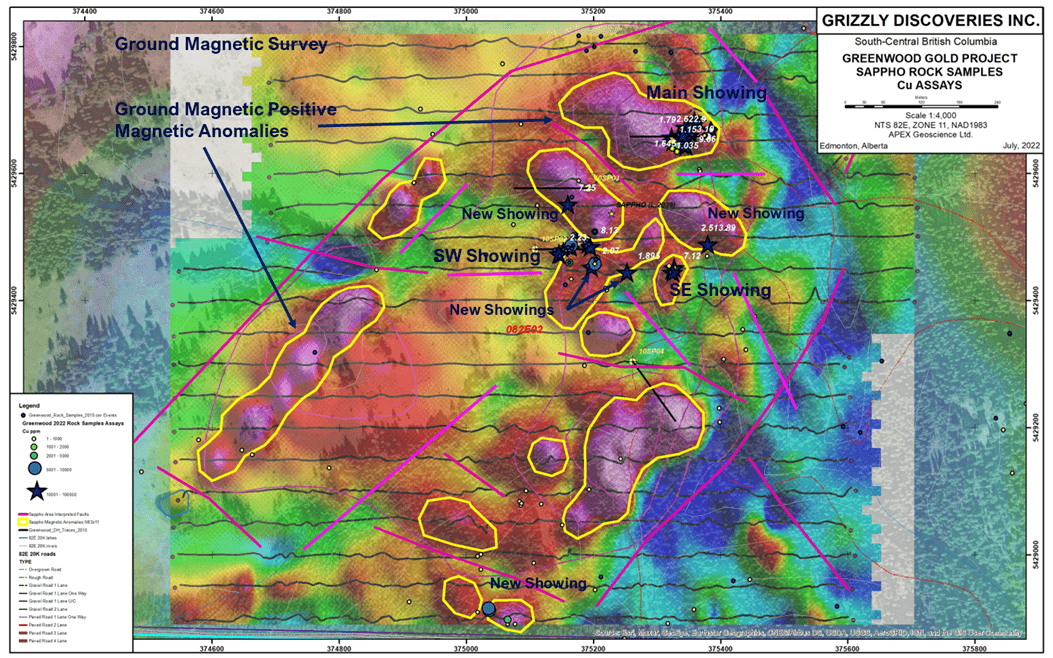
- The Sappho area is being targeted for copper-gold-PGEs skarn and porphyry type targets associated with an alkalic intrusion and several diorite intrusions south of Greenwood near the US border.
- At least five new showings of copper oxide/sulphide mineralization were found during the 2022 program at the Sappho Target.
- Previous surface sampling and drilling by Grizzly at the Sappho area has yielded significant anomalous copper, gold, silver along with platinum and palladium.
- Numerous rock grab samples have yielded greater than 1% copper, 1 g/t gold, 1 g/t platinum and 1 g/t palladium. The sampling work in 2022 yielded 17 rock grab samples with >1% Cu up to 9.06% Cu.
- Historical drilling (by the Company) has yielded up to 0.31% Cu, 0.75 g/t Au, 0.34 g/t Pt, 0.39 g/t Pd and 6.57 g/t Ag over 6.5 m core length in skarn at Sappho in 2010.
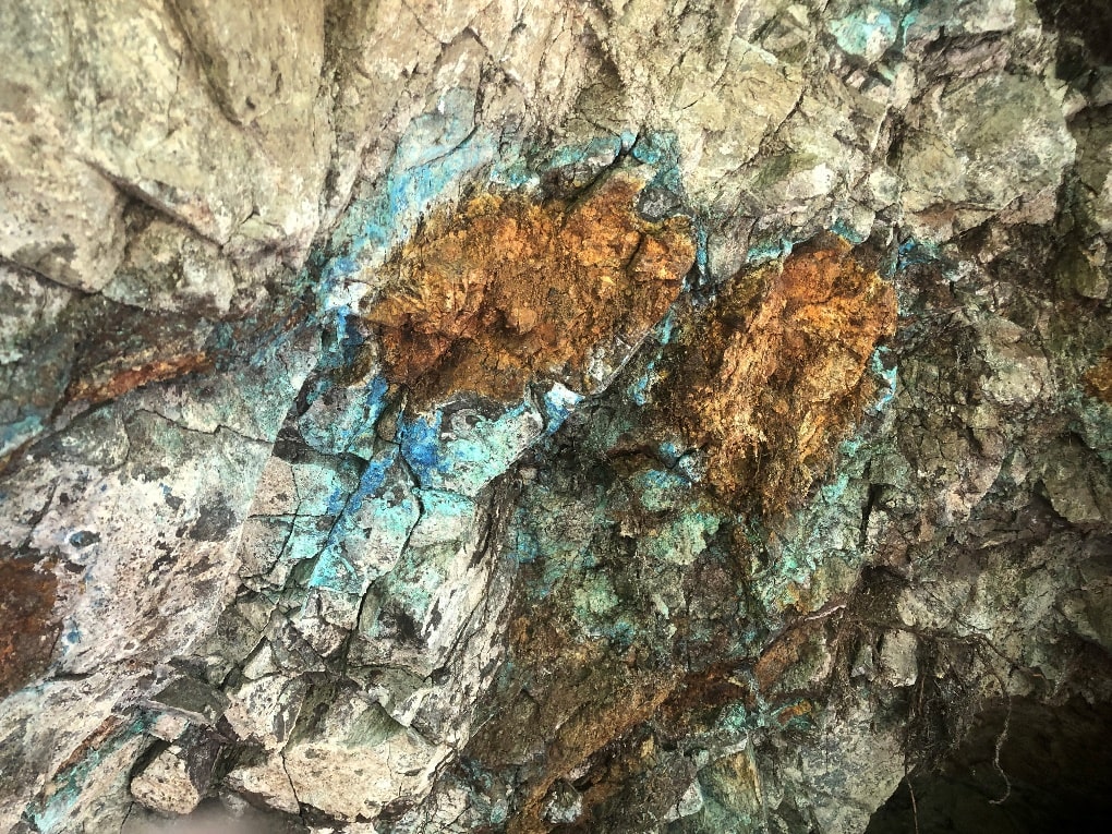
Mineralization at Sappho 2022
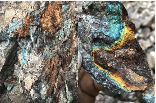
Copper bloom at the Main Sappho Adit Showing
MOTHERLODE
Motherlode was first staked and explored in 1891, with commercial production commencing in 1901. The mine and smelter closed in 1918 due to decreasing ore grades. Woodgreen Copper Mines Ltd. put the Motherlode Mine back in production in 1956 as an open pit operation, and operated the mine until 1962, at which time it was permanently closed.
The historic Motherlode underground and open pit mine produced close to 175,000 ounces of Au, 700,000 ounces of Ag and 77 million pounds of Cu at an average grade of 1.27 g/t Au, 5.04 g/t Ag and 0.82% Cu from a skarn between 1900 and 1962 (British Columbia Minfile 082ESE034).
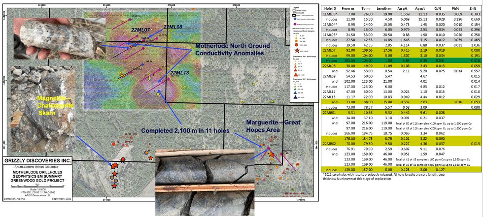
A total of 1,722 m in nine core holes was completed at Motherlode North, approximately 500 to 750 m north of the historical Motherlode copper-gold-silver mine and 387 m in two core holes were completed at the Marguerite Target as part of the 2022 Phase 1 drilling program. The Company announced final results from 2022 exploration drilling at Motherlode North, with the following highlights:
- The Motherlode North polymetallic and skarn targets are comprised of copper-gold-silver +/- lead-zinc (Cu-Au-Ag +/- Pb-Zn) targets 500 to 750 m north and northeast of the historical Motherlode Mine (not owned by the Company), which produced significant amounts of Cu, Au and Ag including 173,000 ounces (oz) of Au, 688,000 oz of Ag and 77 million lbs of Cu between 1896 and 1918 and 1956 to 1963 (BC Minfile 082ESE034).
- Prior drilling by Grizzly intersected up 17.15 g/t Au, 41.7 g/t Ag, along with, 0.56% Pb and 1.51% Zn over 1.5 m core length at one of the skarn targets north of the Motherlode Pit.
- Skarn and sulphide rich mineralization, along with widespread hornfels and propylitic alteration have been intersected in most of the 2022 Motherlode North (22ML07 to 15) and the two (22MR01 & 02) Marguerite core holes.
- Final assay results for the nine Motherlode holes have yielded anomalous Au, Ag, Cu, Pb and Zn in every hole with a best high-grade sample of 5.86 g/t Au and 6.36 g/t Ag over 1 m core length along with several wide low grade intersections in particular adjacent to porphyritic intrusions in Triassic sulphide rich hornfelsed or skarnified Brooklyn sedimentary rocks.
- A number of the Motherlode North holes have yielded wide low grade Au-Ag+/-Cu-Zn intersections such as hole 22ML07 with 0.415 g/t Au, 2.19 g/t Ag, 0.019% Cu and 0.08% Zn over 17.56 m core length, along with hole 22ML08 with 0.108 g/t Au, 2.43 g/t Ag, 0.013% Cu and 0.059% Zn over 11.09 m core length and 0.332 g/t Au, 2.63 g/t Ag and 0.053% Zn over 15 m core length, interpreted to be part of a large alteration footprint in a well mineralized skarn-porphyry system.
- The porphyritic intrusions are widespread and are likely Cretaceous or Eocene in age. Sulphide mineralization with anomalous geochemistry appears to be spatially associated with these intrusions.
- The two holes in the vicinity of the Marguerite historical shaft intersected near surface skarn with anomalous Au-Ag-Cu and deeper hornfelsed sediments and breccias that are silica-sulphide rich and with widespread anomalous Cu over 50 to 100 m in thickness (Holes 22MR01 and 02). The deeper mineralization is associated with propylitic alteration and potentially could highlight deeper copper-gold porphyry potential beneath the Motherlode area skarn system.
- Holes 22MR01 and 22MR02 returned upper skarn related zones of 0.442 g/t Au, 5.61 g/t Ag and 0.028% Cu over 5.32 m, and 0.227 g/t Au, 4.36 g/t Ag and 0.037% Cu over 9.5 m core length.
- The lower highly anomalous copper-gold rich zones are highlighted by 0.123 g/t Au, 2.06 g/t Ag and 0.127% Cu over 8 m core length in hole 22MR02, but this is contained within a 46 m wide zone to the end of the hole where all but 4 of 45 samples yielded >100 ppm Cu up to 1,980 ppm Cu.
- Similarly, in hole 22MR01, there is lower zone of copper rich mineralization that is 119 m in thickness to the end of the hole where 80 of 116 samples yielded >100 ppm Cu up to 1,600 ppm Cu.
- Although low grade, the wide highly anomalous intersections of low to moderate grade gold and copper are likely indicative or part of a large mineralized hydrothermal system.
Motherlode North & Marguerite 2022 Drill Program
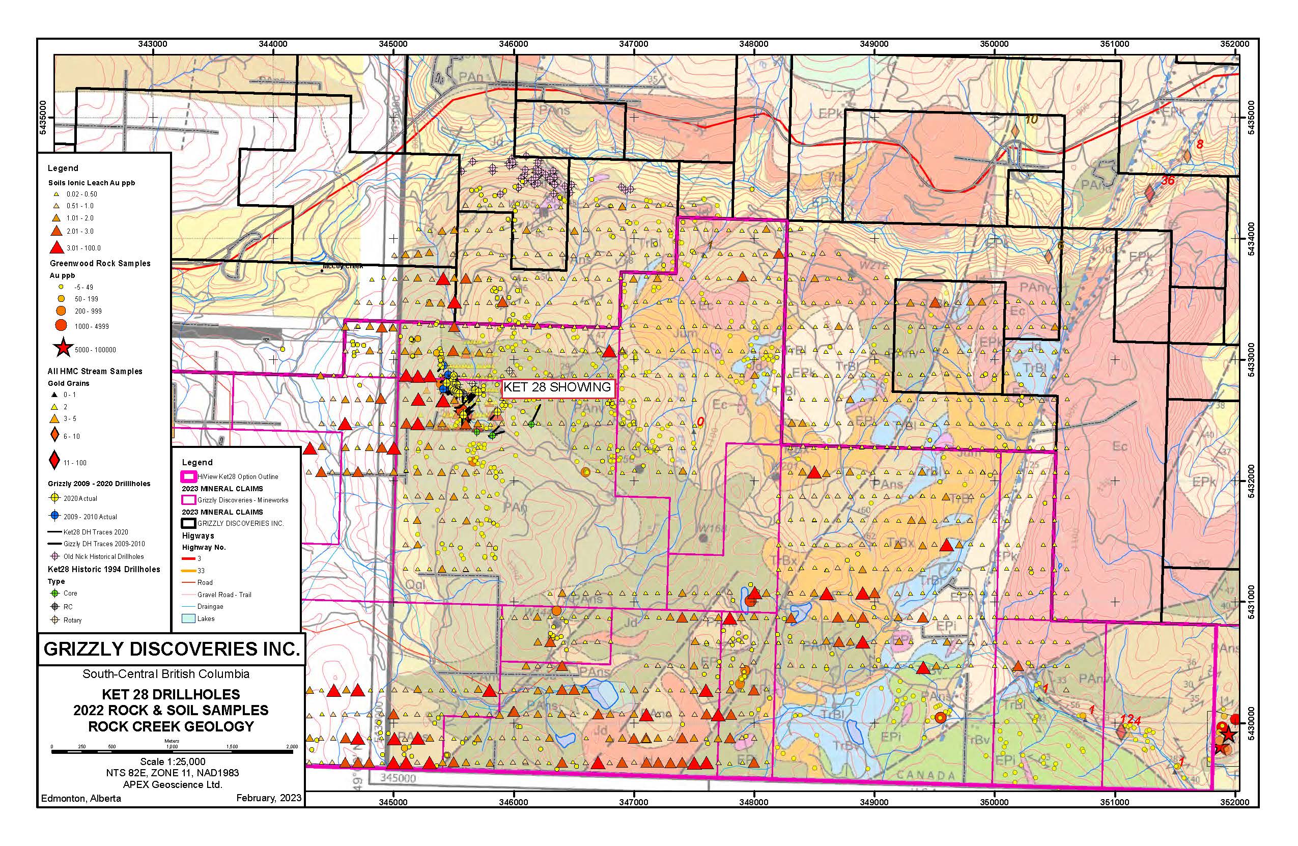
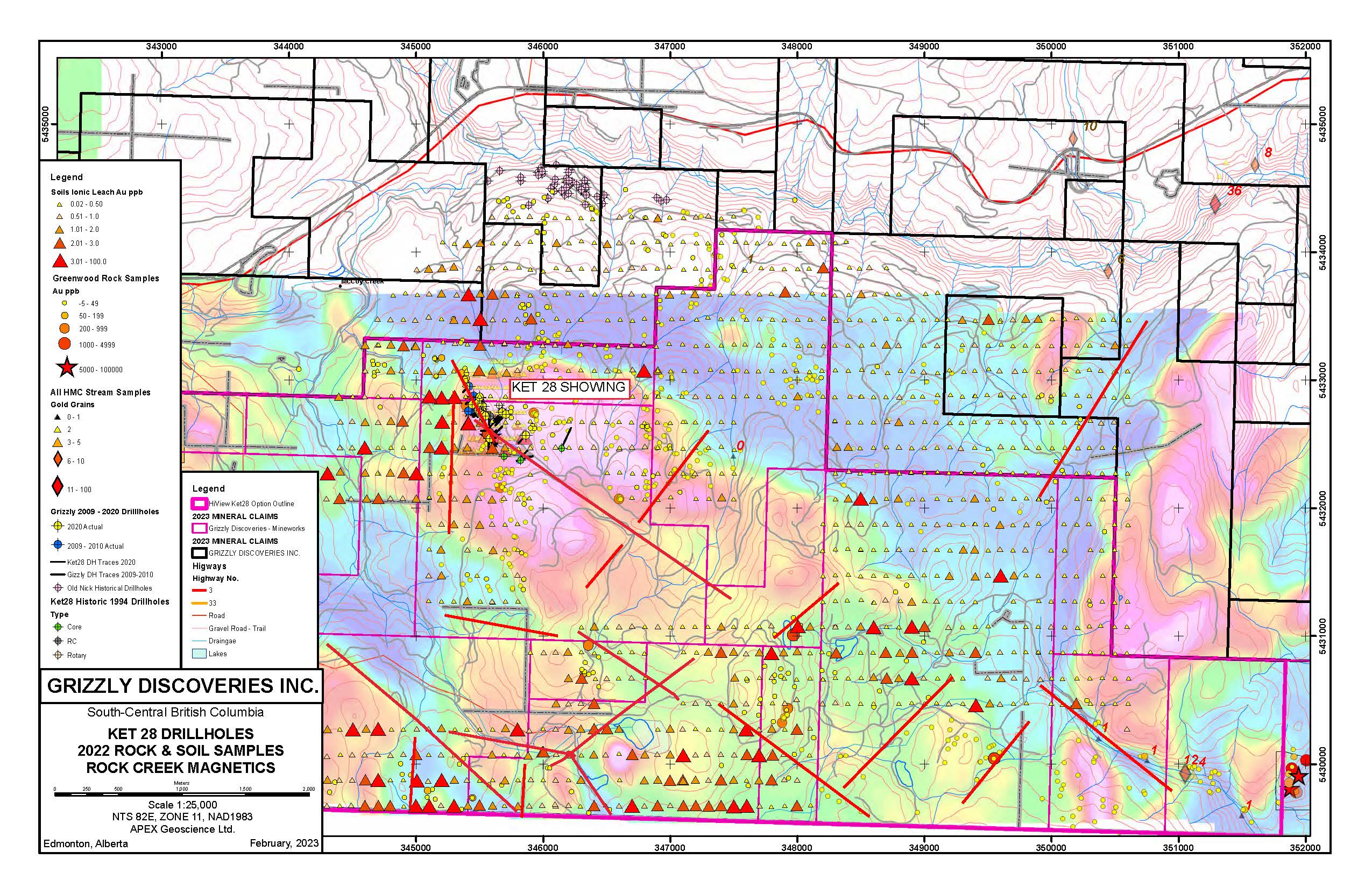
KET 28
The Ket 28 gold target is located in a road accessible, proven and prolific area, adjacent to the US border in south-central British Columbia, Canada.
Highlights for 2022 soil and rock sampling program at the Ket 28 prospect:
- First significant systematic regional sampling program with more than 1,000 soil samples collected...
- New anomalous gold zones in soils identified...
- A total of 129 rock grab samples collected...
- Numerous northwest and northeast controlling structures...
Ket 28 Drillholes, 2022 Rock & Soil Samples, Rock Creek Geology
Ket 28 Drillholes, 2022 Rock & Soil Samples, Rock Creek Magnetics
2020 Drill Program Gold Target Highlights:
- Results from the last nine holes intersecting...
- Results from the first six holes intersecting...
- The Ket 28 Target remains open...
- All drill-holes intersected variable amounts...
- Drilling has expanded the volume and extent...
- Diamond drill program consisted of 1,975m in 15 drill holes
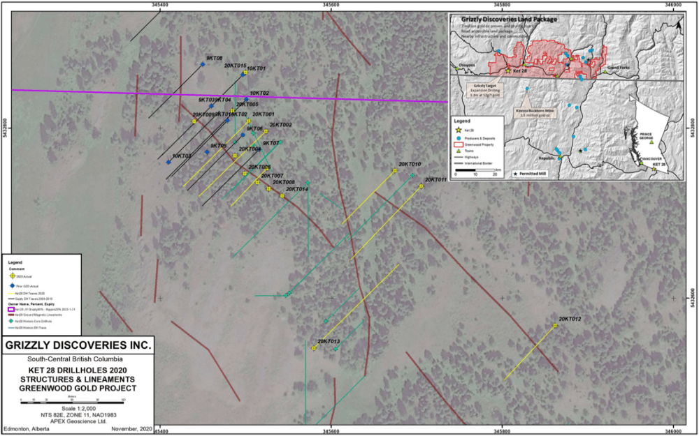
Ket 28 2020 Drill Hole Locations
The Company conducted an exploration program in 2009-2010...
Planned exploration for the Ket 28 includes a program of up to 11 drill holes...
COBALT REVIEW
During late 2017, the Company performed an initial review to see if its land holdings were prospective for the presence of cobalt (Co). The strategic review identified the presence of at least 13 rock grab samples with greater than 0.05%, including up to 0.10% Co, from at least five separate target occurrences across the eastern half of Grizzly's Greenwood Project area. The database shows an additional 31 rock grab samples that have yielded assays of between 0.02 and 0.05% Co. Maps showing the anomalous values and locations for Co at the Greenwood Project:
A preliminary review of the sample database indicates that many of the rock samples with anomalous Co also contain anomalous values for Cu and precious metals including Au and Ag. In many cases, the samples with anomalous Co were collected from Cu-enriched skarn and hornfels developed in Paleozoic sediments and intrusions, where the original sampling targeted precious metals. Grizzly has initiated a property wide review, including its extensive soil and drillhole database along with much of the historic data for the district that it has compiled over the years. The goal will be to target potential Co-Cu-Au-Ag mineralization associated with skarn across the district and come up with targets for follow-up exploration during 2019.
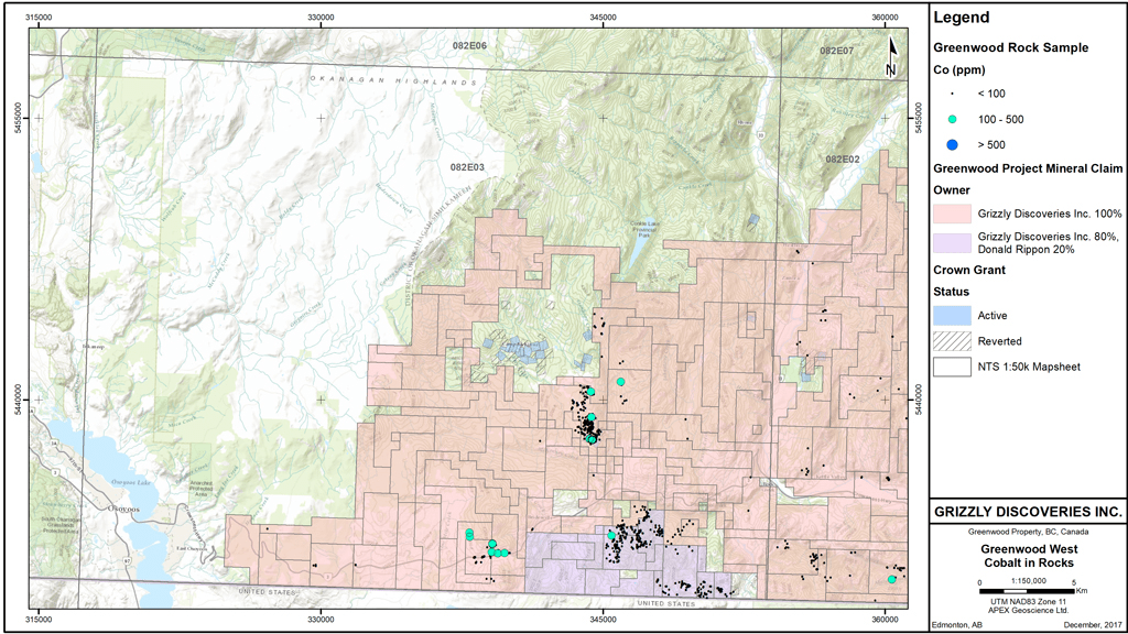
Greenwood West Cobalt in Rocks
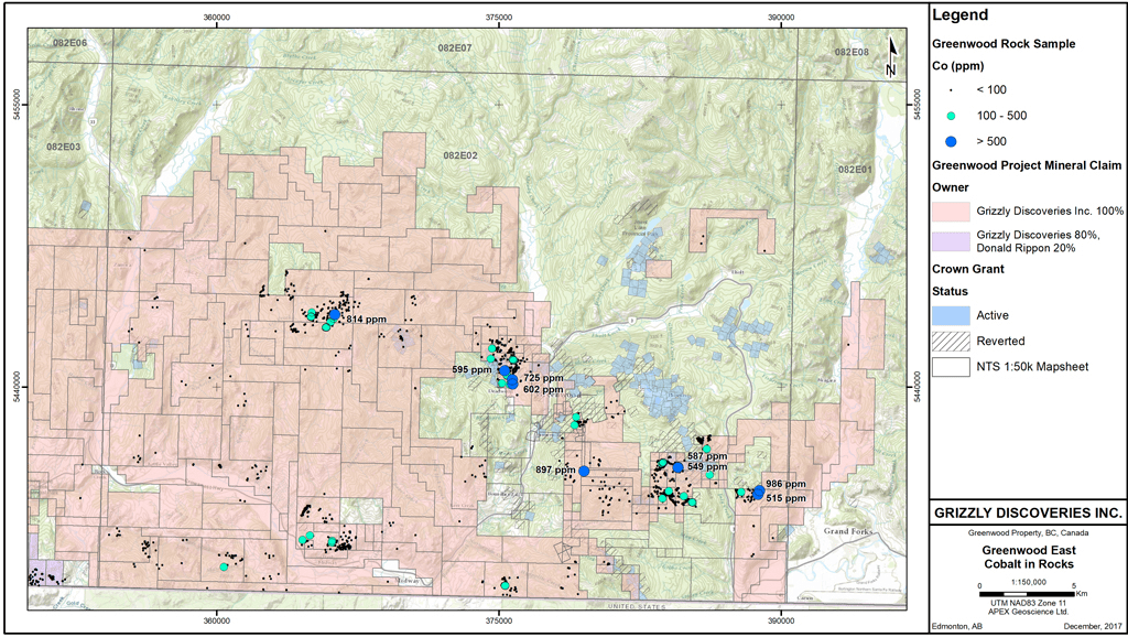
Greenwood East Cobalt in Rocks