IMPERIAL MINE
Discovery of the Imperial area mineralization dates to the late 1890’s with initial production first recorded in the early 1900’s. The historical Imperial Mine has seen intermittent production from the early 1900’s to as recently as 2011. According to the BC Government minfile records the historical Imperial Mine produced a little over 9,200 oz of silver and more than 20,000 pounds each of lead and zinc. The production records cover the period from 1914 to 1949 (BC MINFILE 082ESE113). Details of the total production during the 1990’s through to the 2000’s by the Cannon family is unknown. Open pit and underground mining were conducted during the period.
The historical Imperial Mine, is located on the eastern margin of the Kettle River, is underlain by a complex north-trending graben that exposes Paleozoic metasedimentary and metavolcanic rocks, which were later intruded by Jurassic diorite and granodiorite suites. Extension in the hanging wall terrane on the western margin of the Grand Forks complex led the formation of north-trending grabens and later, to favourable mineralization in the area. In the Eocene, alkalic intrusives, namely megacrystic granites and the Coryell intrusive suite and Eocene and younger coarse sediments and alkalic volcanic rocks filled these grabens. This led to localization of both base- and precious-metal deposits in the area (Höy, 2016).
At the Imperial Mine, the property is bounded to the north and south by the Nelson intrusions, consisting of granodiorite, porphyritic granite and diorite. In some locations, these cut the ultramafic rocks. The east is bordered by the Phoenix Volcanic Group of andesite and basalts. The west is predominantly drift covered in the vicinity of the property (Larabie, 1987). As exposed in the underground workings, mineralization is hosted in magnesium-iron rich carbonitized and silicified ultramafics along with sheared and sericitic greenstones and metasediments of the Upper Paleozoic Anarchist and Knob Hill Groups (BC MINFILE 082ESE113). In the early days of exploration, the mineralized rock was described as altered dolomitic sediment associated with abundant quartz and calcite, which had been altered by a green-coloured mineral, most likely chlorite and/or chromium mica or listwanite (Sloan, 1926).
The economic minerals of interest are mainly galena, sphalerite, and pyrite, all of which contain gold and silver. Mineralization occurs primarily in the carbonates as pods or lenses, and lesser as quartz sulphide veins and banded sulphides. These sulphides are confined to narrow quartz veins (0.3 – 1.0 m wide), along with some thicker pods which vary in dip from 20° to 80°. Precious-metal grades vary considerably throughout the underground workings as shown by assay maps from various exploration activities (e.g., 1925 and 1984) (Larabie, 1987).
Some gold occurs with the silver in the sulphides, along with pyrite and arsenopyrite but gold is also known to occur in a steep set of fractures with quartz veining that cuts orthogonally across the more flat-lying banded sulphide pods. The gold content increases as the fractures trend toward a Eocene Coryell intrusive, a couple of km to the east of the open pit.
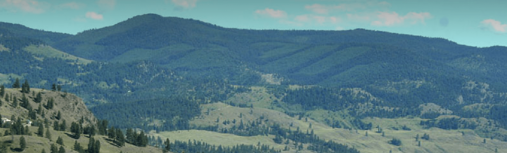
The Imperial Mine target area is 815 ha (2,015 acres) and includes the Riverside Past Producer and Commonwealth showing north of the Imperial Mine. At Riverside, underground workings show that Ag-Pb-Zn+/-Au mineralization is also hosted in the metasedimentary rocks of the Upper Palaeozoic Anarchist and Knob Hill Groups. Polymetallic (Ag-Pb-Zn+/-Au) mineralization occurs in veins and along shears. The historical mine produced nearly as much silver as the Imperial Mine (BC MINFILE 082ESE114). At the Commonwealth showing, about 500 m northeast of the Riverside Past Producer, mineralization consists of pyrite, galena, sphalerite, and mariposite within 0.20 to 2 m wide quartz veins. These vein systems can be divided into two sets: one that strikes north-easterly and dips to the south, and the second, which also strikes north-easterly, but dips flatly to the southeast (BC MINFILE 082ESE115).
Limited Intermittent exploration, including some trenching, diamond drilling and small open pit mining has been conducted over the last 50 years in particular at the historical Imperial Mine. The Company plans to conduct reconnaissance exploration leading to more detailed exploration including additional surface sampling, ground geophysics, potentially underground sampling and eventually drilling and at the Imperial Target area during the upcoming 2023 field season.
At the historical Imperial Mine area, during the 2023 exploration season, a total of 50 new rock grab and rock chip samples were collected from the Imperial showing area, with 6 samples returning greater than 1 (g/t) gold (Au) up to 12.1 g/t Au and 8 samples returning greater than 40 g/t silver (Ag) up to 469 g/t Ag. The samples define a targeted north – south strike length of over 170 m for future drilling (Figure 3). The samples show significant amounts of Pb, Zn and Cu with several samples yielding greater than 2% combined base metals. Geological mapping is in progress and ground geophysical surveys are planned prior to conducting drilling at this target.
In February 2023, the Company announced results from grab samples collected during the exploration season 2022 at the historical Imperial Mine, with the following highlights:
- A total of 83 new selective rock grab and composite rock grab samples collected from a number of outcrops across the 815 hectare (2,015 acre) Imperial Mine target area.
- A total of 10 of the 83 rock grab samples from outcropping mineralization yielding a range from 193 g/t silver (Ag) up to 1,810 g/t Ag (or 5.63 opt up to 52.8 opt Ag) and 1.41 g/t Au up to 11.05 g/t Au.
- The 10 new selective high-grade Ag-Au bearing rock grab samples from the historical Imperial Mine area were collected from five discreet areas of mineralization in and around the historical mine workings including from outcrop and underground.
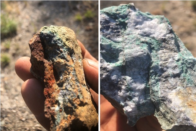
- All highly anomalous samples are characterized by the presence of abundant and visible pyrite, galena and sphalerite in quartz veins and/or pods of silicified metavolcanic or metasedimentary rocks (Greenstones). The mineralization can be described as polymetallic veins and altered wall rock that display the presence of silver, gold, lead, zinc and minor copper and it is likely metasomatic in nature. Granodiorite and diorite intrusions have been noted nearby.
- High levels of chromium and nickel reflect the presence of altered ultramafic rocks with serpentine-carbonate alteration and commonly identified as listwanite.
- The Imperial showings, including the veins and pods of mineralization in the underground, line up north-south to northwest-southeast and are potentially associated with a thrust fault that is broken and somewhat lined up along a north trending structure near the eastern edge of the Rock Creek Graben or the western edge of the Toroda Graben.
- The grabens are characterized by north-northeast trending normal faults.
- The geological setting and style of mineralization at the Imperial Mine bears a strong resemblance to the setting at the Historical Midway Mine about 13.5 km to the southeast.
- The Company is planning surface and underground rock and soil sampling, mapping, ground geophysical surveys and eventually drilling.
Selected geochemical highlights for 24 rock grab samples* collected from the Imperial Mine area.
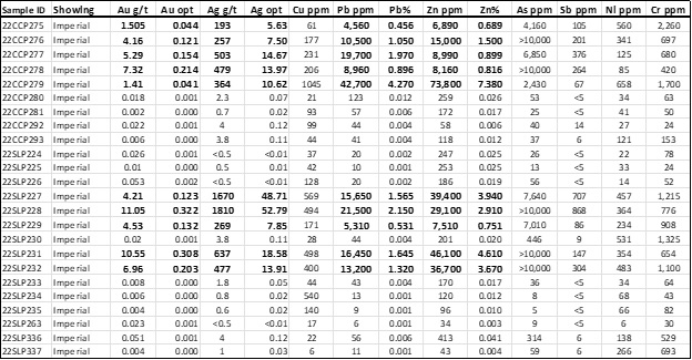
*Selective rock grab samples are illustrative of the tenor of mineralization for the material collected but may or may not be characteristic of the overall mineralization of the zone sampled as they are selective in nature.